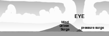
Source: National Weather Center and WFTS |
|
Hurricanes are Categorized from 1 to 5 according to what is known as the Saffir-Simpson Scale. |
|
Category
1 Category
2 Category
3 Category
4
|
Storm surge is the combination of a bubble of ocean water raised above the mean water surface by low pressure contained within the eye and a delicate balance the wind pressure that counters the force gravity applied to a wall of moving water. As the wind speeds vary, the height of the wall of water increases or disperses over open water. Momentum would not be a factor as the wind force providing the push decreases dissipation storm surge off to the sides of the hurricane would occur.
Storm tide is the combined factors of surge and the level of the tide at the hurricane's landfall.

(Courtesy NOAA/Neal Dorst)
Mechanics of the Storm Surge
At least five processes can be involved in altering tide levels during storms. These include the pressure effect, the direct wind effect, the effect of the earth's rotation, the effect of waves, and the rainfall effect (Harris, 1963). The pressure effects of a tropical cyclone will cause the water level in the open ocean to rise in regions of low pressure and fall in regions of high pressure. Wind stresses cause a phenomenon referred to as "wind set-up", which is the tendency for water levels to increase at the downwind shore, and to decrease at the upwind shore. This effect is inversely proportional to depth (Harris, 1963). Wind set-up on an open coast will be driven into bays in the same way as the astronomical tide.
Surge and wave heights on shore are affected by the configuration and bathymetry of the ocean bottom. A narrow shelf, or one that drops steeply from the shoreline and subsequently produces deep water in close proximity to the shoreline tends to produce a lower surge, yet a higher and more powerful wave. This situation is seen along the southeast coast of Florida. The edge of the Floridan Plateau, where the water depths equal 91 meters (300 feet), lies just 3 km off shore of Palm Beach, Florida; just 7 km off shore, the depth plunges to over 180 meters (Lane, 1980).
Conversely, coastlines such as those along Florida's Gulf coast and the Florida Keys have long, gently sloping shelves and shallow water depths. The 180 meter (600-foot) depth contour followed southward from Palm Beach County lies more than 30 km to the east of the upper Keys. On the Gulf side of Florida, the edge of the Floridan Plateau (91 meter depth) lies more than 160 km offshore of Marco Island in Collier County. Florida Bay, lying between the Florida Keys and the mainland, is very shallow; depths typically vary between 0.3 and 2 meters (Lane, 1981). These areas are subject to higher storm surge, but smaller waves.
This difference is because in deeper water, a surge can be dispersed down and away from the hurricane. However, upon entering the shallow, gently sloping shelf, the surge can not be dispersed away, but is driven ashore by the wind stresses of the hurricane. Topography of the land surface is an important element in storm surge extent. Areas such as those seen in southern Florida where the land lies less than a few meters above sea level are at particular risk from storm surge inundation.
Courtesy of Wikipedia
http://en.wikipedia.org/wiki/Storm_surge